
“CONSERVATION IN ANTALYA”
SUSTAINABLE
CONSERVATION of NATURAL, HISTORICAL and CULTURAL ASSETS
Assoc. Prof. Dr. Mehmet TUNÇER
Antalya is located in the west of the Medditerranean region. In ancient times it covered all Pamphylia which means "the land of all tribes". The land really deserves the name since it has witnessed many successive civilizations throughout history. In 1st century BC the Pergamum king Attalus ordered his men to find the most beautiful piece of land on earth; he wanted them to find "heaven on earth". After a long search all over the world, they discovered this land and said "This must be 'Heaven' " and King Attalus founded the city giving it the name "Attaleia". From then on many nations kept their eyes on the city.
When the Romans took over the Pergamene Kingdom, Attaleia became an outstanding Roman city which the great Roman Emperor Hadrian visited in 130 AD; an arch was built in his honour which is now worth seeing. Then came the Byzantines, after which the Seljuk Turks took over the city in 1207 and gave it a different name, Adalya, and built the Yivli Minaret.
The Ottomans followed the Seljuks and finally within the Turkish Republic it became a Turkish city and an important port. Antalya has been growing rapidly since 1960 and its population is 1,146,109 acccording to the 1990 census.
Karain is the only cave known in Anatolia where all the phases of Paleolithic are represented without interruption and that also contains a number of habitation levels.
Karain Cave which is located 30 km far from Antalya on the foot of Mount Can dates from Paleolithic Period.

PHOTO 1. KARAIN CAVE IN ANTALYA (600 000 – 8000 BC – THE PALEOLITHIC PERIOD – STONE AGE)
The skull of a Neanderthal child and the skull and skeleton of Homo sapiens from the Upper Paleolithic have been unearthed in this cave. Pamphylia is the ancient name of the rich and fertile alluvial plain of the rivers Kestros, Eurymedon, and Melas (the modern Aksu, Kopru, and Manavgat Rivers)
Pamphylia belonged to the ancient Hittite empire. The main towns were Estwediiys (later known as Aspendus) and Side.
I. ANTALYA : A RAPID GROWING CITY!
Antalya as a rapidly growing city in recent years, with a potential to fulfill international function, is one of the most important cities from the point of natural and historic/cultural heritage. It has been getting a significant share from the rapid urbanization being experienced. In the period of 1985-1990, Antalya Provincial center, with an urban population growth as 44.84 %, has experienced quite a high population increase when compared to the national average. Annual average population growth rate, with 7.69 % has proceeded at a level almost two times of national urban average.
Antalya Urban Region and Greater City will face a significant development pressure during the period of 1995 - 2015 comprising the plan period. Economic and demographic concentrations may have adverse effects in terms of economic and ecologic points of view, unless necessary measures are taken.
High rise developments and rapid urbanization can be seen at Photo 1 are destroying almost all natural and historical assets.
Kepez and Konyaaltı are occupation of squatter areas. More than 45 000 squatters build on mainly fertile irrigated areas. Kepez; Sütçüler, Habipler, Koyunlar Quarters and Konyaaltı; Çakırlar, Bahtılı and Duralliler Villages; mainly treasury / public land were looted by migrators . Squatters are mainly on public lands (40,2 %) (treasury, vakfs, municipalities)
In the north, environs of Kömürcüler Village irrigated fertile areas were planned before as Akdeniz Organised Industry Area, this wrong land use decision is polluting one of the main water springs : KIRKGÖZLER

PHOTO 2. RAPID URBANISATION IN ANTALYA
II. SCALES AND METHODOLOGY FOR PRESERVING; NATURAL, HISTORICAL / CULTURAL ENVIRONMENT: FROM MASTER TO CONSERVATION PLANS
NATURAL ASSETS IN ANTALYA :
National Parks (Olympos, Thermessos), Natural Preservation Sites (Sarisu, Falez, Düden, Lara), Water springs (Kirkgöz, Duraliler), Sea and sandy beaches (Konyaaltı, Lara), Cliffy sea shore (Falez), Forests (Kepez, Lara, Olimpos), Rivers and Streams, (Aksu, Bogacayi, Düden), Valleys, Fertile Soils (Kırcami and Cakirlar), Orange / Fruit Gardens, Glasshouses etc.
HISTORICAL & CULTURAL ASSETS :
Archaeological Sites (Attalia, Perge, Mygdos, Olbia), Historical/Urban Sites and Vernacular Architectecture, (Inner Citadel, Hasimiscan, Balbey),
Hadrianus Gate (Roman 117 – 138)
Yivli Minare and Karatay Medrese (Seljuk 1219-1250)
Inner Citadel Vernacular Ottoman Architecture and Natural Assets
Inner Citadel (Pergamon, Roman, Seljuk, Otoman Periods)

PHOTO 3 . HISTORIC VERNACULAR ARCHITECTURE OF ANTALYA
One of the main conservation target is to preserve ancient ruins
(Perge, Lyrbotae, Olbia, Magydus, Karain vd) as an “Archaeological Park”
Perge ancient city conservation plan prepared by Ministry of Culture in 1993-94.
Decisions of this plan reflected in Master Plan

Photo 4 : PERGE ANCIENT TOWN MUST BE PRESERVED AS AN ARCHAEOLOGICAL PARK
Natural and historical/cultural heritage conservation policies must be reflected in each scales of Master Plans:
1. Metropoliten Area Sub-Regional Master Plan (1/100 000), (Population and sectoral projections, Scenarios targetting sustainable development),
2. Environmental Arrangement Master Plan (1/25 000) (Structural Plan),
3. Master Plan (1/5000)
ALL PLANS MUST AIM TO REACH TARGETS OF A “SUSTAINABLE CONSERVATION AND DEVELOPMENT” FOR THE ANTALYA METROPOLITEN AREA.
Water basins, forest areas, fertile agrigultural areas, irrigation areas, glasshouse areas are very important in the Master Plan decisions (See Map 1 : Natural Resource Analyses).
In Master Plan “threshold analysis” is very important for to preserve natural and historical assets. Public owned lands are must be reserved for future developments like “mass housing”, “squatter preventing area”, “tourism development area” or other public uses
In years between 1995 - 1998 Antalya Plain, for 2015, was planned by UTTA Ltd. ; according to population, social, economical and spatial targets, tourism developments, natural and cultural assets by main transportation plan and environment projects’ data and settlements’ environment data.
MAIN TARGETS of the STRUCTURAL MASTER PLAN (2015) :
To preserve natural and historic/cultural assets and public lands for the future generations. Treasury owned lands on the north (Kepez) can be used as for to future urban developments (Arsa Ofisi / Land Office) “East development axes” on treasury owned lands: A sub-center planned with 300 000 population. Rural & low density, special conditioned developments for the Kırcami and Çakırlar Area
MAIN CONSERVATION STRATEGIES of the STRUCTURAL MASTER PLAN (2015) :
DECENTRALISATION : To decentralise of urban accumulation with north and east mass housing areas and sub-centers.
SUSTAINABLE DEVELOPMENT : Natural and cultural assets of Antalya are the reasons of its extreme sensitivity and its attractiveness. The said heritage should be kept for next generations. Future economic, demographic and spatial development should not destroy those resources.
CONSERVATION OF CULTURAL HERITAGE AND ACQUISITION OF IDENTITY : Specific archaeological and historical heritage, local cultural values and accumulations should be preserved with utmost care, in order to create the sense of belonging and urban identity; and planning measures promoting cultural development should be taken.

MAP 1 : NATURAL RESOURCE ANALYSES (Fertile Areas, Forests, Shores)
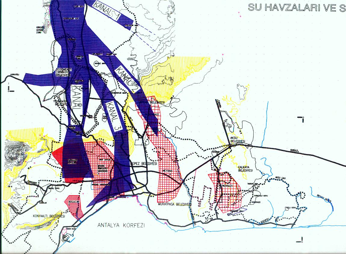
MAP 2 : NATURAL RESOURCE ANALYSES (Water Basins)

MAP 3 : STRATEGIES of The STRUCTURAL AND STRATEGIC MACRO PLAN

MAP 4. MAIN STRATEGIES OF DECENTRALISATION (Mass Housing Areas were planned on the North and East)
Main target and strategies of the Structural Master Plan are to decentralize of urban accumulation towards to North and East Mass Housing Areas and create new Sub-Centers. This decisions will be preserve the sea shores (Konyaaltı, Falez, Lara) and forests (Olimpos and Termessos National Parks on the West/North-West, Kepez Forest on North, Lara and Belek on the East), also preserve valuable agricultural lands (Citrus/Fruit Production, Glasshouses) in and around Çakırlar at the east and Kırcami nearby CBD and Water Basins (Bogaçayi, Duden, Aksu, Bileydi, Duraliler, Kırkgozler etc) (See Map 4. Main Strategies Of Decentralisation)
Because of urban development pressure on those valuable lands, new urban policies needs to develop for suitable areas on North and East
Bu yazı; 28 Haziran - 5 Tem. 2004 arasında, ANTALYA'da, Orta Doğu Teknik Üniversitesi, Bologna University Department of Phlisophy, SANART Association of Aesthetics and Visual Culture, Suna & İnan Kıraç Research Institute on Mediterranean Civilisations tarafından düzenlenen “ ARCHITECTURE IN SITU : WESTERN MEDITERRANEAN COASTAL SETTLEMENTS OF TURKEY, ARCHITECTURE, HISTORY, AESTHETICS”, Summer Seminar’da Davetli Konferans : “CONSERVATION IN ANTALYA” 'da sunulmuştur.


